Difference between revisions of "File:0568.jpg"
[http://www.nga.gov/content/ngaweb/research/casva/research-projects.html A Project of the National Gallery of Art, Center for Advanced Study in the Visual Arts ]
File:0568.jpg
C-tompkins (talk | contribs) |
A-whitlock (talk | contribs) |
||
| Line 1: | Line 1: | ||
| − | + | {{Image | |
| − | + | |Keyword relationships={{Keyword relationship | |
| + | |Keyword relationship=Inscribed | ||
| + | |Keyword=Bath/Bathhouse | ||
| + | }}{{Keyword relationship | ||
| + | |Keyword relationship=Inscribed | ||
| + | |Keyword=Canal | ||
| + | }}{{Keyword relationship | ||
| + | |Keyword relationship=Inscribed | ||
| + | |Keyword=Cemetery/Burying ground/Burial ground | ||
| + | }}{{Keyword relationship | ||
| + | |Keyword relationship=Inscribed | ||
| + | |Keyword=Mall | ||
| + | }}{{Keyword relationship | ||
| + | |Keyword relationship=Inscribed | ||
| + | |Keyword=Pond | ||
| + | }}{{Keyword relationship | ||
| + | |Keyword relationship=Inscribed | ||
| + | |Keyword=Square | ||
| + | }}{{Keyword relationship | ||
| + | |Keyword relationship=Attributed | ||
| + | |Keyword=Public garden/Public ground | ||
| + | }} | ||
| + | |Creator=William Keenan | ||
| + | |Creation Present=No | ||
| + | |Creation Date=September 1844 | ||
| + | |Creation Circa=No | ||
| + | |Creation Concurrence=Exact | ||
| + | |Creation Questionable=No | ||
| + | |Creation HasEndDate=No | ||
| + | |Creation Present End=No | ||
| + | |Creation Circa End=No | ||
| + | |Creation Questionable End=No | ||
| + | |Title=''Plan of the City and Neck of Charleston, S.C.'' | ||
| + | |Medium=lithograph | ||
| + | |Dimensions=18 9/10 x 15 in. (48 x 38 cm) | ||
| + | |Image Title=William Keenan, ''Plan of the City and Neck of Charleston, S.C.'', September 1844 | ||
| + | |Showcase main=No | ||
| + | |Showcase essay=No | ||
| + | |Publication Present=No | ||
| + | |Publication Circa=No | ||
| + | |Publication Concurrence=Exact | ||
| + | |Publication Questionable=No | ||
| + | |Publication HasEndDate=No | ||
| + | |Publication Present End=No | ||
| + | |Publication Circa End=No | ||
| + | |Publication Questionable End=No | ||
| + | }} | ||
William Keenan, ''Plan of the City and Neck of Charleston, S.C.'', September 1844, lithograph, 18 9/10 x 15 in. (48 x 38 cm). David Rumsey Historical Map Collection, Cartography Associates. | William Keenan, ''Plan of the City and Neck of Charleston, S.C.'', September 1844, lithograph, 18 9/10 x 15 in. (48 x 38 cm). David Rumsey Historical Map Collection, Cartography Associates. | ||
Latest revision as of 13:51, August 30, 2021
About this image
Relationships
- Place
- People
- Keyword relationships
- Inscribed: Bath/Bathhouse
- Inscribed: Canal
- Inscribed: Cemetery/Burying ground/Burial ground
- Inscribed: Mall
- Inscribed: Pond
- Inscribed: Square
- Attributed: Public garden/Public ground
Information
- Creator
- William Keenan
- Date
- September 1844
- Title
- Plan of the City and Neck of Charleston, S.C.
- Inscription
- Medium
- lithograph
- Dimensions
- 18 9/10 x 15 in. (48 x 38 cm)
Reference
- Date of Publication
- Reference Title
- Volume
- Edition
- Page
- Figure
- Repository
- Zotero ID
Download an RDF export
William Keenan, Plan of the City and Neck of Charleston, S.C., September 1844, lithograph, 18 9/10 x 15 in. (48 x 38 cm). David Rumsey Historical Map Collection, Cartography Associates.
File history
Click on a date/time to view the file as it appeared at that time.
| Date/Time | Thumbnail | Dimensions | User | Comment | |
|---|---|---|---|---|---|
| current | 19:28, May 18, 2016 | 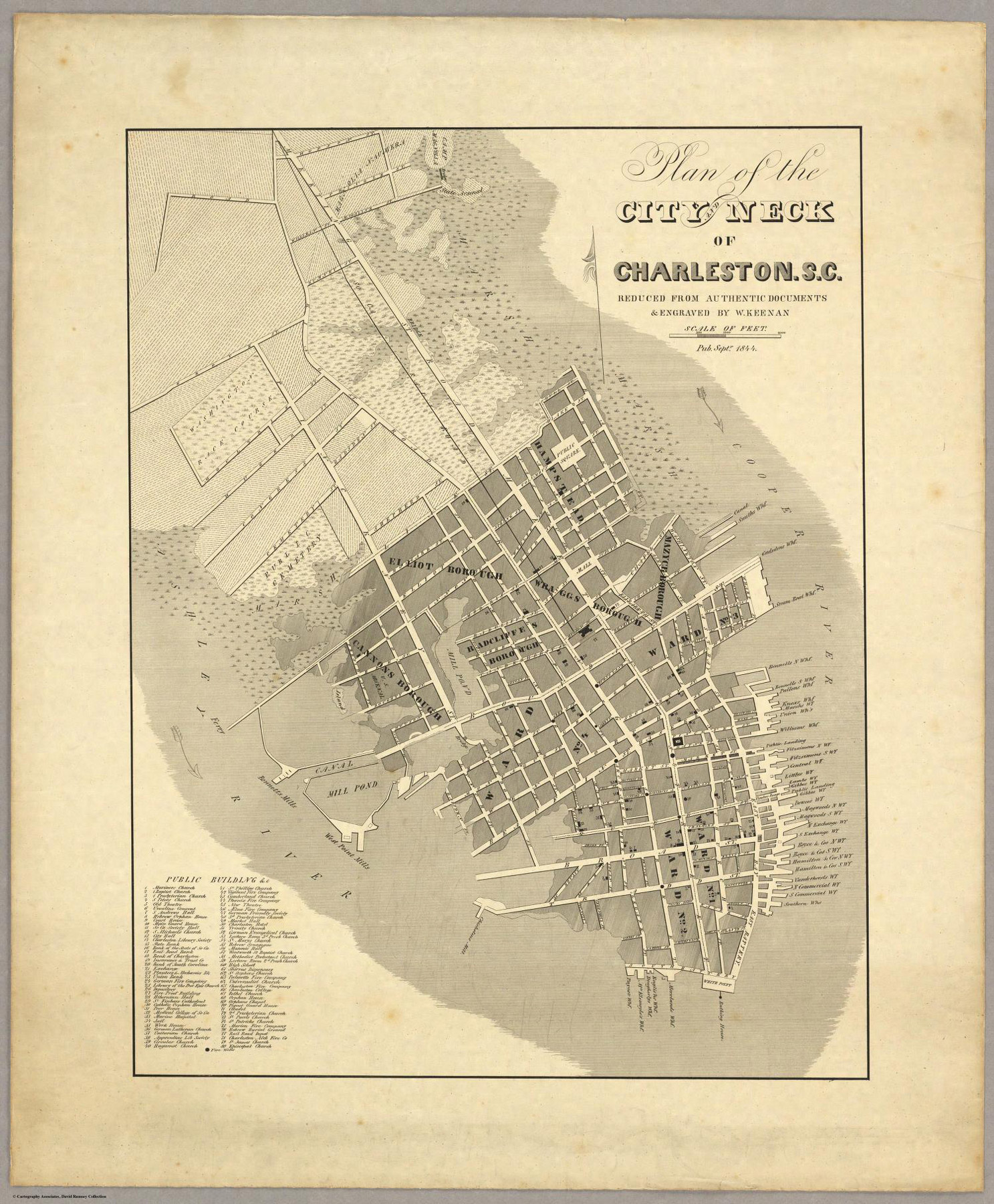 | 1,487 × 1,800 (745 KB) | C-tompkins (talk | contribs) |
You cannot overwrite this file.
File usage
The following 8 pages use this file: